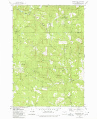
1979 Map of Springer Mtn
USGS Topo · Published 1980About this map
Tillamook State Forest and the Siuslaw National Forest converge in this 1970s survey of the Coast Range at the boundary of Tillamook and Yamhill counties. The landscape is defined by a dense network of timber-access routes including Niagara Road, Bible Creek Access Road, and White Road, which navigate the steep elevations of Springer Mountain and Rye Mountain.
Find a feature on this map
39 named features on this map. Tap any name to fly to it.
Don’t see what you’re looking for? This feature index may not catch every label — zoom into the map to look around manually.
Map Details
Editions of this 1979 Springer Mtn Map
2 editions found
Other maps of this area

1942 · Ginger Peak
USGS Topo · 1:62,500

1942 · Sheridan
USGS Topo · 1:62,500

1942 · Spirit Mtn
USGS Topo · 1:62,500

1942 · Fairdale
USGS Topo · 1:62,500

1948 · Vancouver
USGS Topo · 1:250,000

1950 · Vancouver
USGS Topo · 1:250,000

1950 · Vancouver
USGS Topo · 1:250,000

1955 · Blaine
USGS Topo · 1:62,500

1955 · Fairdale
USGS Topo · 1:62,500

1955 · Grand Ronde
USGS Topo · 1:62,500