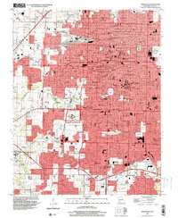
1996 Map of Springfield
USGS Topo · Published 2000About this map
Springfield appears here as a mature regional hub, its urban landscape defined by a dense network of educational institutions and medical facilities. This 1990s perspective shows the significant footprint of the Federal Medical Center and the Southwest Missouri State University campus, alongside smaller private institutions like Drury College and Evangel College. To the west and south, the city gives way to the communities of Nichols and Battlefield, where the terrain is drained by Wilsons Creek and South Creek. The map provides excellent detail for genealogists, recording numerous local landmarks such as Springfield National Cem, St Marys Cem, and Hazelwood Cemetery. From the historic Central High School to the outlying Bethany Ch, the sheet captures the expansion of Greene County's primary city at the close of the century.
Find a feature on this map
74 named features on this map. Tap any name to fly to it.
Don’t see what you’re looking for? This feature index may not catch every label — zoom into the map to look around manually.
Map Details
Editions of this 1996 Springfield Map
This is the sole edition of this map. No revisions or reprints were ever made.
Other maps of this area

1884 · Springfield
USGS Topo · 1:125,000

1886 · Springfield
USGS Topo · 1:125,000

1935 · Springfield
USGS Topo · 1:24,000

1936 · Brookline
USGS Topo · 1:24,000

1937 · Galloway
USGS Topo · 1:24,000

1937 · Ozark
USGS Topo · 1:48,000

1943 · Ozark
USGS Topo · 1:62,500

1945 · Ozark
USGS Topo · 1:62,500

1946 · Bassville
USGS Topo · 1:24,000

1947 · Strafford
USGS Topo · 1:62,500