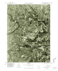
1975 Map of Springfield North
USGS Topo · Published 1981About this map
The Connecticut River carves a dramatic oxbow through the industrial heart of Western Massachusetts in this mid-1970s orthophotoquad. The urban landscapes of Holyoke and South Hadley Falls dominate the western edge, where the river's power once fueled the region's massive paper and textile mills. Moving east, the photographic detail captures the confluence of the Chicopee River and the sprawling residential and commercial development of Chicopee and northern Springfield.
Find a feature on this map
7 named features on this map. Tap any name to fly to it.
Don’t see what you’re looking for? This feature index may not catch every label — zoom into the map to look around manually.
Map Details
Editions of this 1975 Springfield North Map
This is the sole edition of this map. No revisions or reprints were ever made.
Other maps of this area

1885 · Northampton
USGS Topo · 1:62,500

1886 · Springfield
USGS Topo · 1:62,500

1886 · Northampton
USGS Topo · 1:62,500

1887 · Palmer
USGS Topo · 1:62,500

1887 · Belchertown
USGS Topo · 1:62,500

1889 · Springfield
USGS Topo · 1:62,500

1889 · Palmer
USGS Topo · 1:62,500

1890 · Belchertown
USGS Topo · 1:62,500

1891 · Northampton
USGS Topo · 1:62,500

1893 · Northampton
USGS Topo · 1:62,500