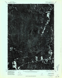
1975 Map of Springfield NW
USGS Topo · Published 1980About this map
The settlement of Springfield anchors the southern portion of this 1975 orthophotograph, where small-scale agriculture and forest clearings disrupt the dense timberland of northern Penobscot County. This aerial perspective, captured in late May, reveals the intricate drainage patterns of the Maine interior, notably the meandering Mattagodus Stream and the waters of Mattakeunk. The remote landscape is dominated by heavy forest cover, punctuated by Webster Pond and a few isolated clearings along the tributary known simply as Branch. This map provides a clear record of the region's mid-century logging and land-use patterns, showing the precise footprint of rural dwellings and field boundaries as they existed before decades of subsequent forest regrowth and development altered the local topography.
Find a feature on this map
5 named features on this map. Tap any name to fly to it.
Don’t see what you’re looking for? This feature index may not catch every label — zoom into the map to look around manually.
Map Details
Editions of this 1975 Springfield NW Map
This is the sole edition of this map. No revisions or reprints were ever made.
Other maps of this area

1920 · Winn
USGS Topo · 1:62,500

1931 · Springfield
USGS Topo · 1:48,000

1934 · Springfield
USGS Topo · 1:62,500

1940 · Mattawamkeag
USGS Topo · 1:62,500

1941 · Wytopitlock
USGS Topo · 1:62,500

1942 · Mattawamkeag
USGS Topo · 1:62,500

1943 · Wytopitlock
USGS Topo · 1:62,500

1954 · Millinocket
USGS Topo · 1:250,000

1958 · Millinocket
USGS Topo · 1:250,000

1960 · Millinocket
USGS Topo · 1:250,000