
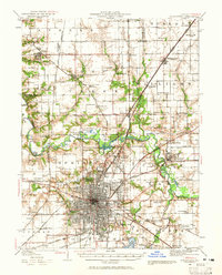
1940 Map of Springfield
USGS Topo · Published 1959About this map
The capital city of Springfield serves as a dense rail hub at the start of the 1940s, situated at the confluence of the Wabash Railroad, Illinois Central RR, and the Baltimore and Ohio RR. The urban center is flanked by established recreation and civic sites, including Washington Park and the State Fair Grounds. To the north, the Sangamon River meanders through a landscape of wetlands like Horseshoe Lake and Halfmoon Lake, providing a sharp contrast to the rigid grid of the city.
Find a feature on this map
100 named features on this map. Tap any name to fly to it.
Don’t see what you’re looking for? This feature index may not catch every label — zoom into the map to look around manually.
Map Details
Editions of this 1940 Springfield Map
2 editions found
Other maps of this area

1907 · Springfield
USGS Topo · 1:62,500

1909 · Tallula
USGS Topo · 1:62,500

1911 · Lincoln
USGS Topo · 1:62,500

1913 · Lincoln
USGS Topo · 1:62,500

1922 · Divernon
USGS Topo · 1:62,500

1923 · Taylorville
USGS Topo · 1:62,500

1924 · Divernon
USGS Topo · 1:62,500

1924 · Waverly
USGS Topo · 1:62,500

1925 · Taylorville
USGS Topo · 1:62,500

1926 · Waverly
USGS Topo · 1:62,500