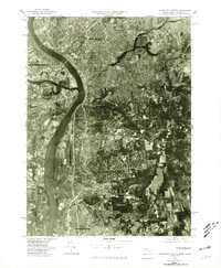
1975 Map of Springfield South
USGS Topo · Published 1981About this map
The Connecticut River serves as the central artery for this mid-1970s orthophotograph, a specialized document that overlays precise topographic surveying onto aerial imagery. This perspective reveals the dense residential and industrial expansion of Springfield and West Springfield during a period of significant post-war development. The aerial view makes it possible to distinguish individual street layouts and building footprints across the riverfront communities of Agawam and Westfield. To the south, the transition into Long Meadow and East Longmeadow shows the established suburban patterns and open spaces nearing the Connecticut border. The inclusion of Thompsonville provides a rare photographic record of the interstate connectivity and landscape character as it existed before decades of further modernization changed the valley's visual profile.
Find a feature on this map
8 named features on this map. Tap any name to fly to it.
Don’t see what you’re looking for? This feature index may not catch every label — zoom into the map to look around manually.
Map Details
Editions of this 1975 Springfield South Map
This is the sole edition of this map. No revisions or reprints were ever made.
Other maps of this area

1886 · Springfield
USGS Topo · 1:62,500

1887 · Palmer
USGS Topo · 1:62,500

1889 · Springfield
USGS Topo · 1:62,500

1889 · Palmer
USGS Topo · 1:62,500

1892 · Hartford
USGS Topo · 1:62,500

1892 · Tolland
USGS Topo · 1:62,500

1893 · Springfield
USGS Topo · 1:62,500

1893 · Palmer
USGS Topo · 1:62,500

1895 · Springfield
USGS Topo · 1:62,500

1896 · Holyoke
USGS Topo · 1:125,000