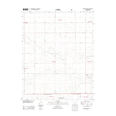
2013 Map of Springfield West
USGS Topo · Published 2013About this map
The southeastern High Plains of Springfield, Colorado, are defined by a network of intermittent drainage and sprawling range land. In the early 21st century, the landscape is bisected by US Hwy 160, which runs along the northern edge of the Comanche National Grassland. The town's western outskirts are anchored by the Baca County Fairground and the Springfield Cem, reflecting the civic and memorial history of this agricultural hub. The terrain is marked by the seasonal paths of Plum Creek, Bear Creek, and Cat Creek, which carve gentle draws across the landscape. Away from the town center, isolated sites like the McEndree Ranch and a grid of county roads, such as Co Road 24, illustrate the enduring rural settlement patterns of Baca County.
Find a feature on this map
40 named features on this map. Tap any name to fly to it.
Don’t see what you’re looking for? This feature index may not catch every label — zoom into the map to look around manually.
Map Details
Editions of this 2013 Springfield West Map
This is the sole edition of this map. No revisions or reprints were ever made.
Other maps of this area

1891 · Springfield
USGS Topo · 1:125,000

1892 · Two Butte
USGS Topo · 1:125,000

1893 · Two Butte
USGS Topo · 1:125,000

1893 · Springfield
USGS Topo · 1:125,000

1955 · La Junta
USGS Topo · 1:250,000

1958 · La Junta
USGS Topo · 1:250,000

1968 · La Junta
USGS Topo · 1:250,000
1971 · Big Rock Grange
USGS Topo · 1:24,000
1971 · Horse Creek Springs
USGS Topo · 1:24,000
1971 · Mc Endree Ranch
USGS Topo · 1:24,000