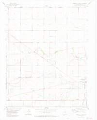
1978 Map of Springfield West
USGS Topo · Published 1979About this map
The western edge of Springfield, Colorado, is documented here in the late 1970s, showing a landscape defined by the intersection of high plains drainage and transit infrastructure. The Atchison Topeka and Santa Fe railroad cuts diagonally across the terrain, running roughly parallel to several intermittent watercourses. Notable local landmarks concentrated on the town's periphery include the County Fairground and a nearby Golf Course, providing a look at the community's recreational layout of the era.
Find a feature on this map
15 named features on this map. Tap any name to fly to it.
Don’t see what you’re looking for? This feature index may not catch every label — zoom into the map to look around manually.
Map Details
Editions of this 1978 Springfield West Map
This is the sole edition of this map. No revisions or reprints were ever made.
Other maps of this area

1891 · Springfield
USGS Topo · 1:125,000

1892 · Two Butte
USGS Topo · 1:125,000

1893 · Two Butte
USGS Topo · 1:125,000

1893 · Springfield
USGS Topo · 1:125,000

1955 · La Junta
USGS Topo · 1:250,000

1958 · La Junta
USGS Topo · 1:250,000

1968 · La Junta
USGS Topo · 1:250,000
1971 · Big Rock Grange
USGS Topo · 1:24,000
1971 · Horse Creek Springs
USGS Topo · 1:24,000
1971 · Mc Endree Ranch
USGS Topo · 1:24,000