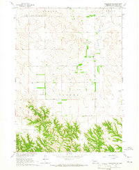
1964 Map of Springview SE
USGS Topo · Published 1965About this map
Keya Paha County's undulating landscape comes into focus during the mid-1960s, showing a region defined by agricultural field lines and remote airstrips. Small-scale aviation appears central to the local geography with both the Stoltenberg Landing Strip in the north and the Gipson Landing Strip further south serving these rural sections. The drainage patterns of Spring Creek, Wyman Creek, and Fairbell Creek carve through the terrain, illustrating the natural water network that supported the townships of Burton, Mills, and Custer. This survey, produced as part of a development program for the Missouri River Basin, captures the exact placement of fences and field lines visible from 1962 aerial photography, providing a precise record of land use before modern pivot irrigation or consolidation altered the rural fabric of northern Nebraska.
Find a feature on this map
12 named features on this map. Tap any name to fly to it.
Don’t see what you’re looking for? This feature index may not catch every label — zoom into the map to look around manually.
Map Details
Editions of this 1964 Springview SE Map
This is the sole edition of this map. No revisions or reprints were ever made.
Other maps of this area

1949 · Jamison SW
USGS Topo · 1:24,000

1949 · Riverview
USGS Topo · 1:24,000

1949 · Carns
USGS Topo · 1:24,000

1950 · Bassett NW
USGS Topo · 1:24,000

1950 · Carns
USGS Topo · 1:24,000

1950 · Riverview
USGS Topo · 1:24,000

1951 · Jamison SW
USGS Topo · 1:24,000

1955 · O'Neill
USGS Topo · 1:250,000

1959 · O'Neill
USGS Topo · 1:250,000

1964 · Mills
USGS Topo · 1:24,000