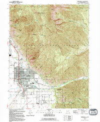
1993 Map of Springville
USGS Topo · Published 1994About this map
Springville and Mapleton sit at the base of the Wasatch Range, where the steep topography of the Uinta National Forest meets the developed valley floor. The map highlights a community defined by its water and agricultural infrastructure, including the State Fish Hatchery and several creeks emerging from deep canyons like Hobble Creek and Slate Canyon. The presence of the Denver and Rio Grande Western railroad and industrial markers such as a Radio Facility and Grain Bins underscore the town's role as a regional transit and processing hub.
Find a feature on this map
85 named features on this map. Tap any name to fly to it.
Don’t see what you’re looking for? This feature index may not catch every label — zoom into the map to look around manually.
Map Details
Editions of this 1993 Springville Map
This is the sole edition of this map. No revisions or reprints were ever made.
Other maps of this area

1885 · Salt Lake
USGS Topo · 1:250,000

1907 · Strawberry Valley
USGS Topo · 1:125,000

1909 · Strawberry Valley
USGS Topo · 1:125,000

1948 · Spanish Fork
USGS Topo · 1:24,000

1948 · Orem
USGS Topo · 1:24,000

1948 · Orem
USGS Topo · 1:62,500

1948 · Springville
USGS Topo · 1:24,000

1948 · Provo
USGS Topo · 1:24,000

1948 · Bridal Veil Falls
USGS Topo · 1:24,000

1949 · Provo
USGS Topo · 1:62,500