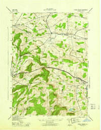
1945 Map of Sprout Brook
USGS Topo · Published 1945About this map
Cherry Valley serves as a primary hub in this mid-century survey, where the Cherry Valley Turnpike cuts through the high ground of the Minden and Canajoharie regions. The landscape is defined by its rural education and burial sites, featuring numerous numbered schools like School No 13 and family-named resting places such as Coleman Cem and Mc Fee Cem. The map reveals a high concentration of small, named settlements including Salt Springville and Leesville, many of which developed around the local water system of Bowmans Creek and Snyder Creek.
Find a feature on this map
41 named features on this map. Tap any name to fly to it.
Don’t see what you’re looking for? This feature index may not catch every label — zoom into the map to look around manually.
Map Details
Editions of this 1945 Sprout Brook Map
This is the sole edition of this map. No revisions or reprints were ever made.
Other maps of this area

1898 · Canajoharie
USGS Topo · 1:62,500

1900 · Canajoharie
USGS Topo · 1:62,500

1902 · Canajoharie
USGS Topo · 1:62,500

1903 · Richfield Springs
USGS Topo · 1:62,500

1904 · Richmondville
USGS Topo · 1:62,500

1907 · Cooperstown
USGS Topo · 1:62,500

1909 · Cooperstown
USGS Topo · 1:62,500

1943 · South Valley
USGS Topo · 1:24,000

1943 · Sharon Springs
USGS Topo · 1:24,000
1943 · Sprout Brook
USGS Topo · 1:24,000