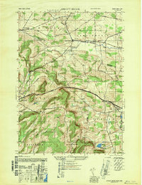
1947 Map of Sprout Brook
USGS Topo · Published 1947About this map
Sharon Springs and Salt Springville anchor this 1940s landscape where the borders of Montgomery, Otsego, and Schoharie counties converge. The terrain is defined by the prominent Cherry Valley ridge, navigated by the historic Cherry Valley Turnpike and Clinton Road. This era reveals a densely settled rural network of one-room schoolhouses, including School No 13 and School No 9, serving isolated hamlets like Hessville and Marshville.
Find a feature on this map
38 named features on this map. Tap any name to fly to it.
Don’t see what you’re looking for? This feature index may not catch every label — zoom into the map to look around manually.
Map Details
Editions of this 1947 Sprout Brook Map
This is the sole edition of this map. No revisions or reprints were ever made.
Other maps of this area

1898 · Canajoharie
USGS Topo · 1:62,500

1900 · Canajoharie
USGS Topo · 1:62,500

1902 · Canajoharie
USGS Topo · 1:62,500

1903 · Richfield Springs
USGS Topo · 1:62,500

1904 · Richmondville
USGS Topo · 1:62,500

1907 · Cooperstown
USGS Topo · 1:62,500

1909 · Cooperstown
USGS Topo · 1:62,500

1943 · South Valley
USGS Topo · 1:24,000

1943 · Sharon Springs
USGS Topo · 1:24,000
1943 · Sprout Brook
USGS Topo · 1:24,000