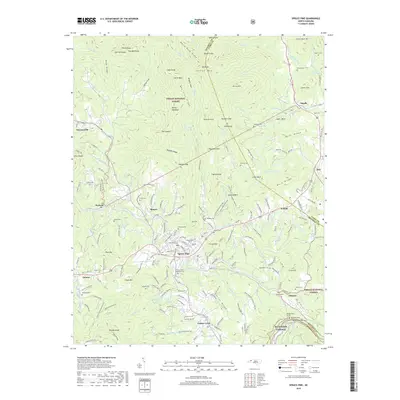
2019 Map of Spruce Pine
USGS Topo · Published 2019About this map
Spruce Pine and the surrounding high country of the Pisgah National Forest define this 2019 survey, showcasing a landscape where deep-rooted Appalachian settlements meet the preserved wilderness of the Blue Ridge. The North Toe River winds through the center of the sheet, connecting towns like Altapass, Estatoe, and Minpro. The map's detail is a boon for genealogists, recording numerous family burying grounds including Wiseman Cem, Stafford Cem, and McHone Cem. The terrain is characterized by prominent peaks and ridges such as Yellow Mtn, Big Bald, and White Rock Ridge, while the presence of Emerald Mine Rd alludes to the region's mineral history. Transportation corridors are marked by the Blue Ridge Parkway and the OMVT Trail, illustrating how modern recreation and historic travel routes traverse the steep elevation changes of the Mitchell and Avery County borders.
Find a feature on this map
109 named features on this map. Tap any name to fly to it.
Don’t see what you’re looking for? This feature index may not catch every label — zoom into the map to look around manually.
Map Details
Editions of this 2019 Spruce Pine Map
This is the sole edition of this map. No revisions or reprints were ever made.
Other maps of this area

1891 · Roan Mountain
USGS Topo · 1:125,000

1893 · Cranberry
USGS Topo · 1:125,000

1894 · Roan Mountain
USGS Topo · 1:125,000

1895 · Cranberry
USGS Topo · 1:125,000

1899 · Cranberry
USGS Topo · 1:125,000

1900 · Mount Mitchell
USGS Topo · 1:125,000

1902 · Cranberry
USGS Topo · 1:125,000

1902 · Mount Mitchell
USGS Topo · 1:125,000

1904 · Roan Mountain
USGS Topo · 1:125,000

1905 · Morganton
USGS Topo · 1:125,000