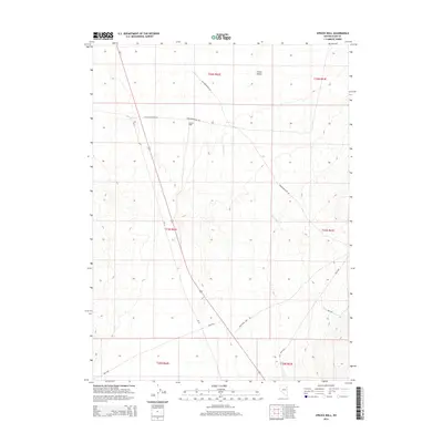
2014 Map of Spruce Well
USGS Topo · Published 2014About this map
Spruce Well serves as a lone landmark in this high-altitude basin of Elko County, documenting the landscape of northeastern Nevada in the early 21st century. The terrain is defined by the transition from the floor of Clover Valley into the sloping foothills, a region where water sources like Laurel Run dictate the historical movement of people and livestock. A network of primitive roads, including Sprucemountain Rd and Old Sprucemont Rd, crisscrosses the township lines of the Public Land Survey System, illustrating how modern administrative access via Bureau of Land Management routes like BLM Road 1528 overlays older, traditional mountain paths. This 2014 survey captures the persistence of remote ranching and grazing infrastructure in a region characterized by wide-open drainage patterns and significant elevation changes.
Find a feature on this map
16 named features on this map. Tap any name to fly to it.
Don’t see what you’re looking for? This feature index may not catch every label — zoom into the map to look around manually.
Map Details
Editions of this 2014 Spruce Well Map
This is the sole edition of this map. No revisions or reprints were ever made.
Other maps of this area
1935 · Halleck
USGS Topo · 1:125,000
1953 · Spruce Mountain
USGS Topo · 1:62,500

1955 · Elko
USGS Topo · 1:250,000

1958 · Elko
USGS Topo · 1:250,000

1962 · Elko
USGS Topo · 1:250,000

1965 · Elko
USGS Topo · 1:250,000
1984 · Arizona Spring
USGS Topo · 1:24,000
1984 · Valley Mtn
USGS Topo · 1:24,000
1984 · Delcer Buttes
USGS Topo · 1:24,000
1984 · Palomino Well
USGS Topo · 1:24,000