
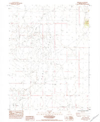
1984 Map of Delcer Buttes
USGS Topo · Published 1984About this map
Delcer Buttes and West Butte dominate this high-desert terrain, where water resources were the primary landmarks for ranchers and travelers in the early 1980s. Evidence of human activity in this arid landscape is concentrated around a few critical points like Frenchy Well and Dry Lake Well, which served as vital hydration stops in the transition between Ruby Valley and Butte Valley. The map shows a region shaped by natural drainage patterns and specialized land use, where Dry Lakes and the expansive Dry Lake Flat characterize the valley floors. Several scattered prospects on the eastern slopes indicate localized mineral exploration, while a Borrow Pit near the range boundary suggests small-scale material extraction for the few unimproved roads that cross this territory.
Find a feature on this map
12 named features on this map. Tap any name to fly to it.
Don’t see what you’re looking for? This feature index may not catch every label — zoom into the map to look around manually.
Map Details
Editions of this 1984 Delcer Buttes Map
This is the sole edition of this map. No revisions or reprints were ever made.
Other maps of this area

1935 · Halleck
USGS Topo · 1:125,000

1953 · Spruce Mountain
USGS Topo · 1:62,500

1955 · Elko
USGS Topo · 1:250,000

1958 · Elko
USGS Topo · 1:250,000

1962 · Elko
USGS Topo · 1:250,000

1965 · Elko
USGS Topo · 1:250,000

1984 · Silo Canyon
USGS Topo · 1:24,000

1984 · West of Delcer Buttes
USGS Topo · 1:24,000

1984 · Valley Mtn
USGS Topo · 1:24,000
1984 · Smith Well
USGS Topo · 1:24,000