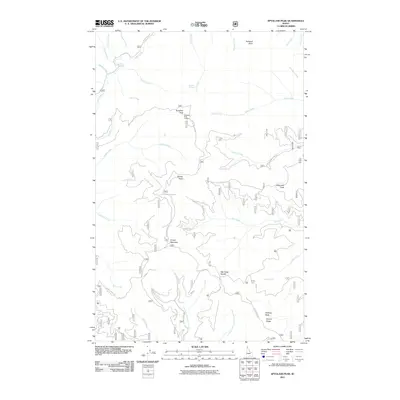
2011 Map of Spyglass Peak
USGS Topo · Published 2011About this map
Spyglass Peak Lookout stands as the central landmark of this mountain landscape in Shoshone County, overseeing a complex network of timber and access roads within the national forest. The 2011 survey details a terrain defined by sharp ridges and deep creek drainages, where routes like Spyglass Peak Rd and Coeur d Alene NF Rd 329 provide the primary infrastructure through the high country. Numerous named summits including Grassy Mountain, Suburban Peak, and Halfway Peak punctuate the ridges above significant watercourses such as Tepee Creek and Flat Creek. The presence of Drexall Spring and the Flat Creek Saddle indicates key topographical waypoints used by foresters and backcountry travelers. This map captures the modern footprint of resource management and recreation in the Idaho Panhandle, preserving the nomenclature of the peaks and the winding forest road system that connects these remote points.
Find a feature on this map
45 named features on this map. Tap any name to fly to it.
Don’t see what you’re looking for? This feature index may not catch every label — zoom into the map to look around manually.
Map Details
Editions of this 2011 Spyglass Peak Map
This is the sole edition of this map. No revisions or reprints were ever made.
Other maps of this area

1909 · Cataldo
USGS Topo · 1:125,000

1911 · Cataldo
USGS Topo · 1:125,000

1955 · Spokane
USGS Topo · 1:250,000

1957 · Kingston
USGS Topo · 1:62,500

1957 · Kellogg
USGS Topo · 1:62,500

1958 · Spokane
USGS Topo · 1:250,000

1961 · Lakeview
USGS Topo · 1:62,500
1966 · Jordan Creek
USGS Topo · 1:24,000
1966 · Cathedral Peak
USGS Topo · 1:24,000
1966 · Spyglass Peak
USGS Topo · 1:24,000