
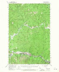
1957 Map of Kellogg
USGS Topo · Published 1959About this map
The Coeur d'Alene River valley serves as the industrial backbone of this 1957 Idaho survey, where the silver and lead mining economy is captured at its mid-century peak. Massive operations like the Bunker Hill Mine, Sunshine Mine, and Galena Mine dominate the landscape south of the river, connected by the Union Pacific railroad and a network of gulch-side settlements. The map documents the tight integration of residential and industrial spaces in Kellogg, Smelterville, and Wardner, where tailings ponds and mines sit in close proximity to neighborhoods and schools. Away from the intense development of the South Fork Coeur d'Alene River, the map transitions into the Coeur d'Alene National Forest, where fire lookouts like Grizzly Mtn and remote peaks such as Character Peak stand over a terrain of steep ridges and creek drainage systems.
Find a feature on this map
136 named features on this map. Tap any name to fly to it.
Don’t see what you’re looking for? This feature index may not catch every label — zoom into the map to look around manually.
Map Details
Editions of this 1957 Kellogg Map
2 editions found
Other maps of this area

1901 · Coeur D'Alene District
USGS Topo · 1:62,500

1903 · Coeur D'Alene District
USGS Topo · 1:62,500

1906 · Coeur D'Alene District
USGS Topo · 1:62,500

1909 · Cataldo
USGS Topo · 1:125,000

1911 · Cataldo
USGS Topo · 1:125,000

1914 · Avery
USGS Topo · 1:125,000

1917 · Avery
USGS Topo · 1:125,000

1932 · Trout Creek
USGS Topo · 1:125,000

1935 · Trout Creek
USGS Topo · 1:125,000

1936 · Trout Creek
USGS Topo · 1:125,000