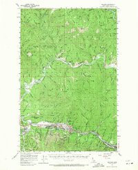
1957 Map of Kellogg
USGS Topo · Published 1971About this map
Industrial mining operations dominate the southern half of this Coeur d'Alene River landscape, where the Union Pacific railroad and the Pacific highway link concentrated settlements along the valley floor. High-elevation extraction sites like the Bunker Hill Mine, Page Mine, and Sunshine Mine underscore the region's historical reliance on silver and lead mining. To the north, the terrain transitions into the steep, forested drainages of the Coeur d'Alene National Forest, characterized by numerous creeks such as Indian Creek and Steam-boat Creek flowing toward the main river. Prominent peaks including Grizzly Mtn and Graham Mtn overlook a network of trails and jeep paths. The concentrated infrastructure around Kellogg and Smelterville, including the County Airport and Bradley Siding, reflects the mid-century industrial peak of Shoshone County.
Find a feature on this map
128 named features on this map. Tap any name to fly to it.
Don’t see what you’re looking for? This feature index may not catch every label — zoom into the map to look around manually.
Map Details
Editions of this 1957 Kellogg Map
2 editions found

Other maps of this area

1901 · Coeur D'Alene District
USGS Topo · 1:62,500

1903 · Coeur D'Alene District
USGS Topo · 1:62,500

1906 · Coeur D'Alene District
USGS Topo · 1:62,500

1909 · Cataldo
USGS Topo · 1:125,000

1911 · Cataldo
USGS Topo · 1:125,000

1914 · Avery
USGS Topo · 1:125,000

1917 · Avery
USGS Topo · 1:125,000

1932 · Trout Creek
USGS Topo · 1:125,000

1935 · Trout Creek
USGS Topo · 1:125,000

1936 · Trout Creek
USGS Topo · 1:125,000