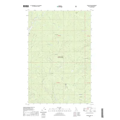
2020 Map of Spyglass Peak
USGS Topo · Published 2020About this map
Spyglass Peak stands as the central landmark of this high-elevation terrain within the Coeur d'Alene National Forest. The landscape is defined by a complex network of ridges and watercourses, where peaks like Halfway Peak, Suburban Peak, and Grassy Mtn overlook deep drainages including Little Elk Creek and Tepee Cr. A network of Forest Service routes, such as Spy Glass Peak Rd and Flat Creek Rd, provide the only access through this backcountry. Evidence of remote aviation and hydrologic monitoring is found at Magee Airport and Drexall Spring. The map captures a moment in the modern management of these Idaho highlands, illustrating how the drainage patterns of Miners Cr and Brett Cr dictate the orientation of both natural ridges like Grizzly Ridge and the historic forest roads that follow them.
Find a feature on this map
54 named features on this map. Tap any name to fly to it.
Don’t see what you’re looking for? This feature index may not catch every label — zoom into the map to look around manually.
Map Details
Editions of this 2020 Spyglass Peak Map
This is the sole edition of this map. No revisions or reprints were ever made.
Other maps of this area

1909 · Cataldo
USGS Topo · 1:125,000

1911 · Cataldo
USGS Topo · 1:125,000

1955 · Spokane
USGS Topo · 1:250,000

1957 · Kingston
USGS Topo · 1:62,500

1957 · Kellogg
USGS Topo · 1:62,500

1958 · Spokane
USGS Topo · 1:250,000

1961 · Lakeview
USGS Topo · 1:62,500
1966 · Jordan Creek
USGS Topo · 1:24,000
1966 · Cathedral Peak
USGS Topo · 1:24,000
1966 · Spyglass Peak
USGS Topo · 1:24,000