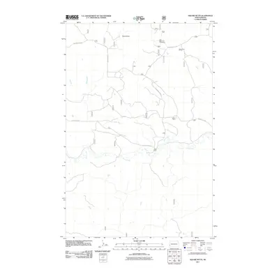
2011 Map of Square Butte
USGS Topo · Published 2011About this map
Square Butte rises above the drainage of Fisher Run and Garner Creek in this portion of Golden Valley County, illustrating the modern rural landscape of western North Dakota. The area's resource-based economy is evidenced by the Square Butte Oil Field in the northeast and established agricultural outposts like Wilson Ranch and Olstad Ranch. The topographic detail shows a network of named roads, including S Square Butte Rd and Garner Creek Rd, which navigate the terrain of the Badlands fringe. Recreational use of the land is noted at Sully Water Hole Campground, situated near the headwaters of seasonal watercourses. This survey provides a precise look at the sparse but significant human footprint in the region, from ranching operations to energy infrastructure, centered around the prominent geological feature of the butte itself.
Find a feature on this map
36 named features on this map. Tap any name to fly to it.
Don’t see what you’re looking for? This feature index may not catch every label — zoom into the map to look around manually.
Map Details
Editions of this 2011 Square Butte Map
This is the sole edition of this map. No revisions or reprints were ever made.
Other maps of this area

1953 · Dickinson
USGS Topo · 1:250,000

1957 · Dickinson
USGS Topo · 1:250,000

1970 · Medora
USGS Topo · 1:24,000

1979 · Sentinel Butte SE
USGS Topo · 1:24,000
1979 · Buffalo Gap Campground
USGS Topo · 1:24,000
1979 · Chimney Butte
USGS Topo · 1:24,000

1979 · Square Butte
USGS Topo · 1:24,000

1979 · Bullion Butte
USGS Topo · 1:24,000
1980 · Sentinel Butte
USGS Topo · 1:24,000

1980 · Alpha
USGS Topo · 1:24,000