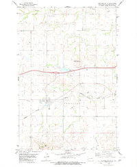
1980 Map of Sentinel Butte
USGS Topo · Published 1980About this map
Sentinel Butte serves as the primary hub of this Golden Valley County landscape, where the Burlington Northern railroad corridor parallels the path of Andrews Creek. The topography is defined by significant high points, most notably Camels Hump Butte and the eponymous sentinel-like formations that give the region its name. Small-scale resource extraction is evident at the Scoria Pit and a Gravel Pit, reflecting the local geology and road-building needs of the time.
Find a feature on this map
22 named features on this map. Tap any name to fly to it.
Don’t see what you’re looking for? This feature index may not catch every label — zoom into the map to look around manually.
Map Details
Editions of this 1980 Sentinel Butte Map
This is the sole edition of this map. No revisions or reprints were ever made.
Other maps of this area

1953 · Dickinson
USGS Topo · 1:250,000

1953 · Watford City
USGS Topo · 1:250,000

1957 · Dickinson
USGS Topo · 1:250,000

1957 · Watford City
USGS Topo · 1:250,000

1967 · Watford City
USGS Topo · 1:250,000

1974 · West Twin Butte
USGS Topo · 1:24,000
1974 · Hootowl Creek SW
USGS Topo · 1:24,000

1974 · Wannagan Creek West
USGS Topo · 1:24,000

1979 · Sentinel Butte SE
USGS Topo · 1:24,000
1979 · Buffalo Gap Campground
USGS Topo · 1:24,000