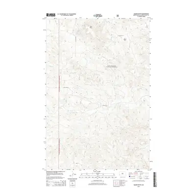
2014 Map of Square Butte
USGS Topo · Published 2014About this map
Little Missouri National Grassland dominates this portion of Golden Valley County, where the high plains of western North Dakota are etched by seasonal waterways. The landscape is defined by the prominent Square Butte, a distinct geological landmark rising above the surrounding draws and ridges. Human activity in this remote area is primarily shaped by natural resource extraction and ranching access, evidenced by the Square Butte Oil Field and a network of gravel roads including Square Butte Rd and Garner Creek Rd. Drainage patterns are dictated by intermittent streams such as Fisher Run, Garner Cr, and Dry Cr, which carve through the badlands-style terrain. This 2014 survey documents the modern footprint of the energy industry within the federal grassland, showing how well sites and access routes intersect with the drainage basins of the Little Missouri river system.
Find a feature on this map
11 named features on this map. Tap any name to fly to it.
Don’t see what you’re looking for? This feature index may not catch every label — zoom into the map to look around manually.
Map Details
Editions of this 2014 Square Butte Map
This is the sole edition of this map. No revisions or reprints were ever made.
Other maps of this area
1953 · Dickinson
USGS Topo · 1:250,000
1957 · Dickinson
USGS Topo · 1:250,000
1970 · Medora
USGS Topo · 1:24,000
1979 · Sentinel Butte SE
USGS Topo · 1:24,000
1979 · Buffalo Gap Campground
USGS Topo · 1:24,000
1979 · Chimney Butte
USGS Topo · 1:24,000
1979 · Square Butte
USGS Topo · 1:24,000
1979 · Bullion Butte
USGS Topo · 1:24,000
1980 · Sentinel Butte
USGS Topo · 1:24,000
1980 · Alpha
USGS Topo · 1:24,000