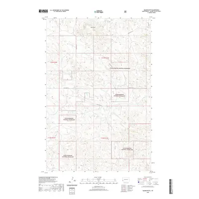
2020 Map of Square Butte
USGS Topo · Published 2020About this map
Little Missouri National Grassland dominates this landscape in Golden Valley County, where the high plains are carved by a network of intermittent drainage ways. The topographic prominent point of Square Butte stands as a primary landmark in the northern portion of the quadrangle, overlooking a terrain defined by the winding paths of Fisher Run and Garner Cr. A sparse network of rural routes, including Square Butte Rd and Garner Creek Rd, provides the only structural indicators of human presence in this open range. This map documents the complex intersection of township boundaries like t139n r103w and t138n r104w within the federally protected grasslands. The absence of concentrated settlements highlights the area's continued use for grazing and conservation, where seasonal water sources like Dry Cr dictate the character of the environment.
Find a feature on this map
14 named features on this map. Tap any name to fly to it.
Don’t see what you’re looking for? This feature index may not catch every label — zoom into the map to look around manually.
Map Details
Editions of this 2020 Square Butte Map
This is the sole edition of this map. No revisions or reprints were ever made.
Other maps of this area

1953 · Dickinson
USGS Topo · 1:250,000

1957 · Dickinson
USGS Topo · 1:250,000

1970 · Medora
USGS Topo · 1:24,000

1979 · Sentinel Butte SE
USGS Topo · 1:24,000
1979 · Buffalo Gap Campground
USGS Topo · 1:24,000
1979 · Chimney Butte
USGS Topo · 1:24,000

1979 · Square Butte
USGS Topo · 1:24,000

1979 · Bullion Butte
USGS Topo · 1:24,000
1980 · Sentinel Butte
USGS Topo · 1:24,000

1980 · Alpha
USGS Topo · 1:24,000