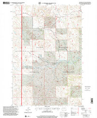
1997 Map of Square Butte
USGS Topo · Published 2001About this map
Little Missouri National Grassland dominates this portion of the Badlands, where the landscape is defined by the high elevations of Square Butte and the plateau of Sentinel Butte. The terrain is marked by a complex network of seasonal drainage, including Fisher Run and Garner Creek, reflecting a remote ranching and energy-producing environment. The Olstad Ranch stands as a rare named settlement in this sparsely populated region, surrounded by active industrial features such as the Square Butte Oil Field and scattered oil wells. This 1997 revision highlights the infrastructure of the late 20th-century energy economy, showing numerous drill holes and a significant Pipeline cutting across the southern terrain. Navigation through the breaks and buttes relies on local routes like South Square Butte Road and Garner Creek Road, which provide access to reliable livestock water sources like Sullys Water Hole.
Find a feature on this map
22 named features on this map. Tap any name to fly to it.
Don’t see what you’re looking for? This feature index may not catch every label — zoom into the map to look around manually.
Map Details
Editions of this 1997 Square Butte Map
This is the sole edition of this map. No revisions or reprints were ever made.
Other maps of this area

1953 · Dickinson
USGS Topo · 1:250,000

1957 · Dickinson
USGS Topo · 1:250,000

1970 · Medora
USGS Topo · 1:24,000

1979 · Sentinel Butte SE
USGS Topo · 1:24,000
1979 · Buffalo Gap Campground
USGS Topo · 1:24,000
1979 · Chimney Butte
USGS Topo · 1:24,000

1979 · Square Butte
USGS Topo · 1:24,000

1979 · Bullion Butte
USGS Topo · 1:24,000
1980 · Sentinel Butte
USGS Topo · 1:24,000

1980 · Alpha
USGS Topo · 1:24,000