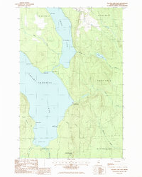
1986 Map of Square Lake East
USGS Topo · Published 1986About this map
Square Lake and Cross Lake dominate this northern Maine landscape, connected by the narrow waterway of The Carry. The shoreline is dotted with remote outposts such as Fraser Camp and Gorfinkle Camp, reflecting a mid-1980s era of seasonal residency and wilderness access in Westmanland and the surrounding unorganized townships. The terrain is defined by low-lying points such as Swede Point, Rocky Point, and Salmon Point, which reach into the deep basins of the lakes. To the east, the elevation rises sharply toward Square Lake Ridge, where a network of streams including McClusky Brook and Butler Brook drain the interior woods. This survey captures a moment when the regional infrastructure remained minimal, consisting primarily of unimproved roads, a transmission line, and a isolated Roadside Park, preserving the character of the Aroostook County backcountry.
Find a feature on this map
33 named features on this map. Tap any name to fly to it.
Don’t see what you’re looking for? This feature index may not catch every label — zoom into the map to look around manually.
Map Details
Editions of this 1986 Square Lake East Map
This is the sole edition of this map. No revisions or reprints were ever made.
Other maps of this area

1927 · Stockholm
USGS Topo · 1:48,000

1927 · Square Lake
USGS Topo · 1:48,000

1929 · Portage
USGS Topo · 1:62,500

1929 · Caribou
USGS Topo · 1:48,000

1931 · Square Lake
USGS Topo · 1:62,500

1931 · Portage
USGS Topo · 1:62,500

1931 · Stockholm
USGS Topo · 1:62,500

1932 · Caribou
USGS Topo · 1:62,500

1953 · Stockholm
USGS Topo · 1:62,500

1953 · Square Lake
USGS Topo · 1:62,500
Featured Places
- Square Lake, ME
- Westmanland, ME
- Burnt Landing, Square Lake
- Cross Lake Township, ME
- Sinclair Township, ME