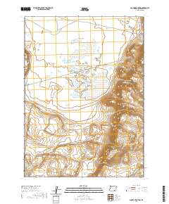
2020 Map of Square Mountain
USGS Topo · Published 2020About this map
Catlow Valley and the high elevations of the Basque Hills define this high-desert region of Harney County, Oregon. The landscape is characterized by its essential water sources for ranching and livestock, including the Lee Morris Spring, Catlow Spring, and the seasonal collection points at The Troughs. To the east, the dramatic elevation change at Catlow Rim leads up to Square Mountain and the McDade Cache, revealing a topography shaped by steep canyons and flat basins like Raz Lewis Flat. Evidence of land management and transportation is found in the path of the CCC RD and Funnel Canyon Rd, while the Stockwater Ditch and reservoirs such as Rock-Knoll Reservoir reflect the ongoing effort to capture and direct water across this arid terrain.
Find a feature on this map
24 named features on this map. Tap any name to fly to it.
Don’t see what you’re looking for? This feature index may not catch every label — zoom into the map to look around manually.
Map Details
Editions of this 2020 Square Mountain Map
This is the sole edition of this map. No revisions or reprints were ever made.
Other maps of this area

1955 · Adel
USGS Topo · 1:250,000

1957 · Adel
USGS Topo · 1:250,000

1958 · Adel
USGS Topo · 1:250,000

1962 · Adel
USGS Topo · 1:250,000
1971 · Square Mountain
USGS Topo · 1:24,000
1971 · Fields Basin
USGS Topo · 1:24,000
1971 · Coyote Gap SE
USGS Topo · 1:24,000
1971 · Garrison Lake
USGS Topo · 1:24,000
1971 · Coyote Gap
USGS Topo · 1:24,000
1971 · Acty Mountain NE
USGS Topo · 1:24,000