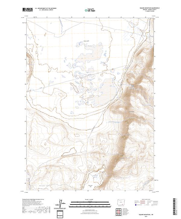
2023 Map of Square Mountain
USGS Topo · Published 2023About this map
Catlow Valley dominates this high-desert landscape in Harney County, illustrating the remote ranching and grazing infrastructure common to southeastern Oregon. Water management is a primary focus of this topographic study, with features such as Stockwater Ditch, The Trough, and the Rock Knoll Reservoir dotting the arid terrain. The landscape transitions from the flat expanse of Raz Lewis Flat and the Basque Hills in the southwest to the dramatic elevation of Catlow Rim and Square Mtn in the east. Local history is subtly recorded in family-named landmarks like Lee Morris Spring and McDade Cache. Access through this isolated region is defined by the CCC RD, a legacy of early 20th-century public works, and the main corridor of Catlow Valley Rd, which skirts the base of the eastern highlands.
Find a feature on this map
26 named features on this map. Tap any name to fly to it.
Don’t see what you’re looking for? This feature index may not catch every label — zoom into the map to look around manually.
Map Details
Editions of this 2023 Square Mountain Map
This is the sole edition of this map. No revisions or reprints were ever made.
Other maps of this area

1955 · Adel
USGS Topo · 1:250,000

1957 · Adel
USGS Topo · 1:250,000

1958 · Adel
USGS Topo · 1:250,000

1962 · Adel
USGS Topo · 1:250,000

1971 · Square Mountain
USGS Topo · 1:24,000

1971 · Fields Basin
USGS Topo · 1:24,000

1971 · Coyote Gap SE
USGS Topo · 1:24,000

1971 · Garrison Lake
USGS Topo · 1:24,000
1971 · Coyote Gap
USGS Topo · 1:24,000
1971 · Acty Mountain NE
USGS Topo · 1:24,000