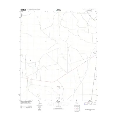
2012 Map of Square Top Mountain
USGS Topo · Published 2012About this map
Square Top Mtn and Rattlesnake Butte anchor this West Texas landscape in Upton County, where a network of rural roads and ephemeral watercourses defines the terrain. The map details a transition between dry mesas and the low-lying drainages of Rankin Draw and China Draw in the northeastern section. Transportation in this arid region relies on a grid of county roads, including Co RD-445 and Co RD-420, which navigate around the prominent natural landmarks. The seasonal flow of Fivemile Cr winds through the eastern portion of the survey, illustrating the typical drainage patterns of the Edwards Plateau. This 2012 survey provides a clear view of the sparse human footprint, centered largely on the infrastructure of Ranch Road 2463 and its connecting local routes.
Find a feature on this map
15 named features on this map. Tap any name to fly to it.
Don’t see what you’re looking for? This feature index may not catch every label — zoom into the map to look around manually.
Map Details
Editions of this 2012 Square Top Mountain Map
This is the sole edition of this map. No revisions or reprints were ever made.
Other maps of this area
1928 · Crane
USGS Topo · 1:125,000
1928 · Rankin
USGS Topo · 1:125,000
1954 · Pecos
USGS Topo · 1:250,000
1954 · San Angelo
USGS Topo · 1:250,000
1957 · Pecos
USGS Topo · 1:250,000
1958 · San Angelo
USGS Topo · 1:250,000
1965 · San Angelo
USGS Topo · 1:250,000
1970 · Cedar Canyon
USGS Topo · 1:24,000
1970 · Sevenmile Corner
USGS Topo · 1:24,000
1970 · Rankin
USGS Topo · 1:24,000