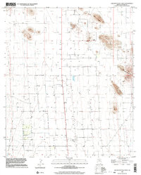
1996 Map of Squaretop Hills West
USGS Topo · Published 2003About this map
Mining operations and water infrastructure define this arid landscape in Cochise County, documented through topography compiled in the late 1970s and imagery from 1996. The eastern edge is dominated by the Squaretop Hills and Ash Creek Ridge, where numerous Prospects, a Mine Shaft, and multiple Mine Shafts indicate a history of mineral exploration. Drainage for the area is facilitated by Ash Creek, while numerous wells and scattered water tanks support local ranching or industrial activity.
Find a feature on this map
12 named features on this map. Tap any name to fly to it.
Don’t see what you’re looking for? This feature index may not catch every label — zoom into the map to look around manually.
Map Details
Editions of this 1996 Squaretop Hills West Map
This is the sole edition of this map. No revisions or reprints were ever made.
Other maps of this area

1916 · Pearce
USGS Topo · 1:125,000

1922 · Swisshelm
USGS Topo · 1:62,500

1925 · Gleeson
USGS Topo · 1:62,500

1926 · Light
USGS Topo · 1:62,500

1926 · Courtland
USGS Topo · 1:62,500

1955 · Douglas
USGS Topo · 1:250,000

1958 · Squaretop Hills
USGS Topo · 1:62,500

1958 · Swisshelm Mtn
USGS Topo · 1:62,500

1958 · Pearce
USGS Topo · 1:62,500
1958 · Gleeson
USGS Topo · 1:62,500