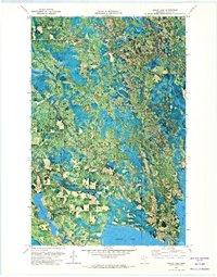
1971 Map of Squaw Lake
USGS Topo · Published 1974About this map
The Chippewa National Forest and the Leech Lake Indian Reservation Boundary intersect in this lake-heavy portion of northern Minnesota. This orthophotomap, derived from 1969 aerial photography, reveals the intricate relationship between the water-saturated landscape and the primary settlements of Squaw Lake and Dunbar. The terrain is dominated by the Popple River and a network of wetlands connecting Hamrey Lake, Dunbar Lake, and the large expanse of Round Lake. Local infrastructure is visible in the form of a Town Hall and a Gravel Pit, providing evidence of the small-scale civic and industrial activity in this timbered region during the early 1970s. The detail of the orthophotomap allows for a clear distinction between dense forest cover and the cleared areas surrounding the principal roads and watercourses like Wagner Creek.
Find a feature on this map
14 named features on this map. Tap any name to fly to it.
Don’t see what you’re looking for? This feature index may not catch every label — zoom into the map to look around manually.
Map Details
Editions of this 1971 Squaw Lake Map
2 editions found
Other maps of this area

1919 · Rosy
USGS Topo · 1:62,500

1919 · Gemmell
USGS Topo · 1:62,500

1919 · Max
USGS Topo · 1:62,500

1919 · Bridgie
USGS Topo · 1:62,500

1924 · Bridgie
USGS Topo · 1:62,500

1954 · Bemidji
USGS Topo · 1:250,000

1957 · Bemidji
USGS Topo · 1:250,000

1958 · Bemidji
USGS Topo · 1:250,000

1971 · Squaw Lake
USGS Topo · 1:24,000

1971 · Dixon Lake
USGS Topo · 1:24,000