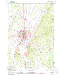
1964 Map of St. Albans
USGS Topo · Published 1987About this map
St Albans serves as the focal point of this Vermont landscape, showing the city's growth along the Central Vermont rail lines during the mid-1960s. The map illustrates a dense collection of civic institutions, including the Bellows Free Academy, Kerbs Hospital, and the Court House, framed by the rising elevations of Aldis Hill. Beyond the city limits, the terrain transitions into a mix of active quarries and rural cemeteries such as Warner Cem and Kattle Cem, reflecting the area's ancestral and industrial foundations.
Find a feature on this map
70 named features on this map. Tap any name to fly to it.
Don’t see what you’re looking for? This feature index may not catch every label — zoom into the map to look around manually.
Map Details
Editions of this 1964 St. Albans Map
3 editions found
Other maps of this area

1913 · Milton
USGS Topo · 1:48,000

1914 · St. Albans
USGS Topo · 1:48,000

1915 · Milton
USGS Topo · 1:62,500

1916 · St. Albans
USGS Topo · 1:62,500

1920 · Franklin Pond
USGS Topo · 1:62,500

1922 · Enosburg Falls
USGS Topo · 1:48,000

1924 · Enosburg Falls
USGS Topo · 1:62,500

1925 · Mount Mansfield
USGS Topo · 1:48,000

1927 · Mount Mansfield
USGS Topo · 1:62,500

1943 · St. Albans
USGS Topo · 1:62,500