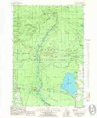
1985 Map of St. Jacques
USGS Topo · Published 1985About this map
The Sturgeon River meanders southward through the heart of the Hiawatha National Forest, defining the landscape of this portion of Delta County. The river’s path is marked by features like Tenmile Rapids and the Fourteenmile Bridge, illustrating its role as a central corridor for wilderness transit and recreation. On the eastern side of the sheet, the significant waters of Moss Lake and smaller bodies like Cache Lake and Little Moss Lake punctuate the timberlands.
Find a feature on this map
29 named features on this map. Tap any name to fly to it.
Don’t see what you’re looking for? This feature index may not catch every label — zoom into the map to look around manually.
Map Details
Editions of this 1985 St. Jacques Map
This is the sole edition of this map. No revisions or reprints were ever made.
Other maps of this area

1932 · Rapid River NE
USGS Topo · 1:31,680

1932 · Garden NW and SW
USGS Topo · 1:31,680

1932 · Skeels Lake SE
USGS Topo · 1:31,680

1932 · Garden SE
USGS Topo · 1:31,680

1932 · Trenary SE
USGS Topo · 1:31,680

1932 · Rapid River SE
USGS Topo · 1:31,680

1932 · Skeels Lake NW and SW
USGS Topo · 1:31,680

1932 · Garden NE
USGS Topo · 1:31,680

1954 · Escanaba
USGS Topo · 1:250,000

1957 · Escanaba
USGS Topo · 1:250,000