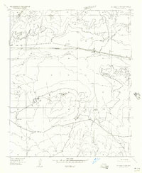
1955 Map of St. Joseph 2 NW
USGS Topo · Published 1957About this map
The Little Colorado River winds through this high desert terrain in Navajo County during the mid-1950s, a period when the regional landscape was defined by the intersection of vital transit routes and sparse ranching infrastructure. The Atchison Topeka and Santa Fe railroad serves as the primary East-West artery, paralleling the river and passing through the small settlement of Manila. This survey reveals a landscape adapted for livestock, marked by numerous water features such as McDonald Spring and several strategically placed Stock Tanks. Prominent landforms like Apache Butte and Hugo Meadow provide navigational landmarks in a territory where drainage systems like Manila Wash and McDonald Canyon dictate the movement of both water and travelers through the arid plains.
Find a feature on this map
11 named features on this map. Tap any name to fly to it.
Don’t see what you’re looking for? This feature index may not catch every label — zoom into the map to look around manually.
Map Details
Editions of this 1955 St. Joseph 2 NW Map
This is the sole edition of this map. No revisions or reprints were ever made.
Other maps of this area

1883 · Tusayan
USGS Topo · 1:250,000

1886 · Tusayan
USGS Topo · 1:250,000

1886 · Holbrook
USGS Topo · 1:250,000

1893 · Holbrook
USGS Topo · 1:250,000

1947 · Flagstaff
USGS Topo · 1:250,000

1954 · Winslow
USGS Topo · 1:62,500

1954 · Winslow 4 SE
USGS Topo · 1:24,000

1954 · Flagstaff
USGS Topo · 1:250,000

1954 · Holbrook
USGS Topo · 1:250,000

1955 · Mal Pais Springs 3 SW
USGS Topo · 1:24,000