1959 Map of St. Paul
USGS Topo · Published 1959About this map
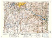
The Minneapolis and Saint Paul metropolitan area stands at the heart of this 1950s regional survey, showing the Twin Cities before the full expansion of the modern interstate system. The landscape is defined by the confluence of the Mississippi River, Minnesota River, and St Croix River, which supported a dense network of river-and-rail commerce. Beyond the urban centers, the map documents the established agricultural and industrial corridors reaching toward Rochester and Mankato.
Find a feature on this map
100 named features on this map. Tap any name to fly to it.
Don’t see what you’re looking for? This feature index may not catch every label — zoom into the map to look around manually.
Map Details
Editions of this 1959 St. Paul Map
2 editions found

Other maps of this area

1896 · Minneapolis
USGS Topo · 1:62,500

1896 · St. Paul
USGS Topo · 1:62,500

1901 · Minneapolis
USGS Topo · 1:62,500

1902 · White Bear
USGS Topo · 1:62,500

1902 · Anoka
USGS Topo · 1:62,500

1905 · Minnetonka
USGS Topo · 1:62,500

1907 · Minnetonka
USGS Topo · 1:62,500

1909 · Rockford
USGS Topo · 1:62,500

1929 · Durand
USGS Topo · 1:62,500

1932 · Cochrane
USGS Topo · 1:62,500