
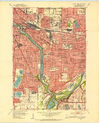
1951 Map of St. Paul West
USGS Topo · Published 1953About this map
The Twin Cities landscape is defined by the winding confluence of the Mississippi River and the Minnesota River at the dawn of the 1950s. This survey captures a dense institutional and academic corridor, featuring the sprawling University of Minnesota and the University of Minnesota Agricultural College, alongside the State Fairgrounds. To the south, the massive Fort Snelling Reservation and the Wold-Chamberlain Airport occupy the strategic high ground above the river junction.
Find a feature on this map
169 named features on this map. Tap any name to fly to it.
Don’t see what you’re looking for? This feature index may not catch every label — zoom into the map to look around manually.
Map Details
Editions of this 1951 St. Paul West Map
2 editions found
Other maps of this area

1896 · Minneapolis
USGS Topo · 1:62,500

1896 · St. Paul
USGS Topo · 1:62,500

1901 · Minneapolis
USGS Topo · 1:62,500

1902 · White Bear
USGS Topo · 1:62,500

1902 · Anoka
USGS Topo · 1:62,500

1951 · Inver Grove
USGS Topo · 1:24,000

1951 · St. Paul SW
USGS Topo · 1:24,000

1951 · St. Paul East
USGS Topo · 1:24,000

1951 · St. Paul
USGS Topo · 1:62,500

1952 · White Bear Lake West
USGS Topo · 1:24,000