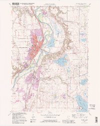
1991 Map of St. Peter
USGS Topo · Published 1995About this map
St Peter sits prominently along the western banks of the Minnesota River, serving as a regional center for education and institutional care. The campus of Gustavus Adolphus College dominates the western bluffs, while the sprawling St Peter State Hospital grounds and Resurrection Cem mark the southern expansion of the city. Along the river valley, the Traverse Des Sioux Park preserves the site of a historic crossing, adjacent to the Chicago and North Western Railroad corridor.
Find a feature on this map
47 named features on this map. Tap any name to fly to it.
Don’t see what you’re looking for? This feature index may not catch every label — zoom into the map to look around manually.
Map Details
Editions of this 1991 St. Peter Map
2 editions found
Other maps of this area

1950 · Mankato East
USGS Topo · 1:62,500

1951 · Mankato East
USGS Topo · 1:62,500

1951 · Mankato West
USGS Topo · 1:62,500

1953 · Saint Paul
USGS Topo · 1:250,000

1953 · New Ulm
USGS Topo · 1:250,000

1957 · New Ulm
USGS Topo · 1:250,000

1958 · New Ulm
USGS Topo · 1:250,000

1959 · Saint Paul
USGS Topo · 1:250,000

1965 · Cleveland
USGS Topo · 1:24,000

1965 · Norseland
USGS Topo · 1:24,000