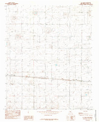
1985 Map of St Vrain
USGS Topo · Published 1985About this map
St Vrain and Grier serve as the primary landmarks in this 1980s snapshot of the High Plains in Curry County. The landscape is defined by a sparse settlement pattern typical of the eastern New Mexico ranching and farming corridor, where wide-open spaces are punctuated by numerous Well sites and isolated homesteads. A central transportation artery carries travelers past a local Roadside Park near the western edge of the quadrangle. Significant for its rural aviation infrastructure, a designated Landing Strip sits just south of the main road, reflecting the necessity of aerial access in this expansive territory. This provisional survey captures the transition of the region before modern development, preserving the locations of critical water sources and transportation stops that supported the local community during the mid-1980s.
Find a feature on this map
5 named features on this map. Tap any name to fly to it.
Don’t see what you’re looking for? This feature index may not catch every label — zoom into the map to look around manually.
Map Details
Editions of this 1985 St Vrain Map
This is the sole edition of this map. No revisions or reprints were ever made.
Other maps of this area

1954 · Clovis
USGS Topo · 1:250,000

1957 · Portair
USGS Topo · 1:62,500

1957 · Melrose
USGS Topo · 1:62,500

1957 · Hammond Ranch
USGS Topo · 1:62,500

1958 · Clovis
USGS Topo · 1:250,000

1972 · Melrose East
USGS Topo · 1:24,000

1973 · Field SE
USGS Topo · 1:24,000
1973 · Melrose SE
USGS Topo · 1:24,000

1985 · Portair
USGS Topo · 1:24,000
1985 · Garrett Ranch
USGS Topo · 1:24,000