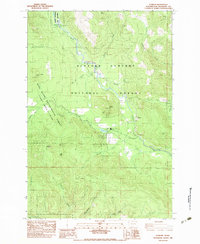
1983 Map of Stabler
USGS Topo · Published 1983About this map
The Wind River flows south through the heart of the Gifford Pinchot National Forest, anchoring a landscape defined by forestry research and conservation in the early 1980s. The settlement of Stabler sits near the junction of several mountain drainages, serving as a gateway to the Wind River Ranger Station and the specialized grounds of the Wind River Arboretum and Wind River Nursery. This area is notable for its concentration of ecological study sites, specifically the Wind River Experimental Forest (Trout Creek Division), which blankets the western slopes above Trout Creek.
Find a feature on this map
33 named features on this map. Tap any name to fly to it.
Don’t see what you’re looking for? This feature index may not catch every label — zoom into the map to look around manually.
Map Details
Editions of this 1983 Stabler Map
This is the sole edition of this map. No revisions or reprints were ever made.
Other maps of this area

1926 · Hood River
USGS Topo · 1:125,000

1929 · Hood River
USGS Topo · 1:125,000

1940 · Lookout Mtn
USGS Topo · 1:62,500

1948 · Vancouver
USGS Topo · 1:250,000

1950 · Vancouver
USGS Topo · 1:250,000

1950 · Vancouver
USGS Topo · 1:250,000

1953 · Lookout Mtn
USGS Topo · 1:62,500

1953 · The Dalles
USGS Topo · 1:250,000

1954 · Bridal Veil
USGS Topo · 1:62,500

1956 · The Dalles
USGS Topo · 1:250,000