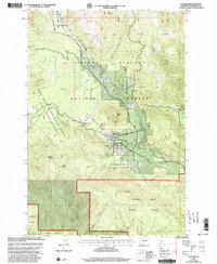
1998 Map of Stabler
USGS Topo · Published 2003About this map
The Gifford Pinchot National Forest dominates this 1998 landscape, revealing a highly managed and scientific approach to the timberlands of southwest Washington. At its heart lies the Wind River Experimental Forest and the Wind River Arboretum, representing some of the earliest forestry research in the Pacific Northwest. The settlement of Stabler serves as a small hub amidst the dense terrain, positioned near the confluence of Martha Creek and the Wind River. To the north, the Carson National Fish Hatchery utilizes Little Soda Spring and the river's flow for conservation efforts. This map documents a period of transition where traditional resources meet modern recreation and conservation, evidenced by the presence of the Pacific Crest National Scenic Trail and the southern reach of the Yacolt Burn State Forest.
Find a feature on this map
61 named features on this map. Tap any name to fly to it.
Don’t see what you’re looking for? This feature index may not catch every label — zoom into the map to look around manually.
Map Details
Editions of this 1998 Stabler Map
This is the sole edition of this map. No revisions or reprints were ever made.
Other maps of this area

1926 · Hood River
USGS Topo · 1:125,000

1929 · Hood River
USGS Topo · 1:125,000

1940 · Lookout Mtn
USGS Topo · 1:62,500

1948 · Vancouver
USGS Topo · 1:250,000

1950 · Vancouver
USGS Topo · 1:250,000

1950 · Vancouver
USGS Topo · 1:250,000

1953 · Lookout Mtn
USGS Topo · 1:62,500

1953 · The Dalles
USGS Topo · 1:250,000

1954 · Bridal Veil
USGS Topo · 1:62,500

1956 · The Dalles
USGS Topo · 1:250,000