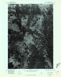
1975 Map of Stacyville SW
USGS Topo · Published 1980About this map
Kelloch Mountain and Whetstone Mountain dominate the wooded interior of Penobscot County in this mid-1970s orthophotograph. This specific type of survey, captured from aerial imagery taken on October 9, 1975, provides a direct visual of the dense forest canopy and natural drainages typical of the Maine North Woods before later development or harvesting altered the landscape. The south-western portion of the quadrangle reveals the shoreline of Millinocket Lake, a major hydrologic feature in a region defined by its timber and water resources. Between the high points, Millinocket Ridge forms a distinct topographic spine, offering a look at the untouched terrain character that defined this area's geography during the latter half of the twentieth century.
Find a feature on this map
4 named features on this map. Tap any name to fly to it.
Don’t see what you’re looking for? This feature index may not catch every label — zoom into the map to look around manually.
Map Details
Editions of this 1975 Stacyville SW Map
This is the sole edition of this map. No revisions or reprints were ever made.
Other maps of this area

1927 · Katahdin
USGS Topo · 1:48,000

1930 · Katahdin
USGS Topo · 1:62,500

1949 · Katahdin
USGS Topo · 1:62,500

1951 · Norcross
USGS Topo · 1:62,500

1951 · Millinocket
USGS Topo · 1:62,500

1953 · Stacyville
USGS Topo · 1:62,500

1954 · Millinocket
USGS Topo · 1:250,000

1958 · Millinocket
USGS Topo · 1:250,000

1960 · Millinocket
USGS Topo · 1:250,000
1975 · Stacyville NW
USGS Topo · 1:24,000