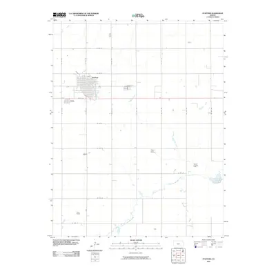
2009 Map of Stafford
USGS Topo · Published 2009About this map
The grid-patterned streets of Stafford anchor this central Kansas landscape, where the town serves as a hub for the surrounding agricultural plains. Waterways like Dooleyville Creek and Peace Creek cut across the section lines, while the North Fork Ninnescah River meanders through the southern reaches of the quadrangle. For those researching local heritage, the map identifies both Stafford Cemetery near the town center and the more isolated Pleasant Valley Cemetery to the southeast. The terrain is largely flat, punctuated by Pilot Knob in the southwest corner. Transportation and utility are represented by the Newell Landing Field and the small catchment of Rosacker Lake, illustrating the rural infrastructure of the early 21st century. The map's detailed road network, including names like Mincer Ave and Martin Ave, provides a clear view of the area's modern spatial organization.
Find a feature on this map
31 named features on this map. Tap any name to fly to it.
Don’t see what you’re looking for? This feature index may not catch every label — zoom into the map to look around manually.
Map Details
Editions of this 2009 Stafford Map
This is the sole edition of this map. No revisions or reprints were ever made.
Other maps of this area

1891 · Great Bend
USGS Topo · 1:125,000

1892 · Kingman
USGS Topo · 1:125,000

1892 · Pratt
USGS Topo · 1:125,000

1893 · Great Bend
USGS Topo · 1:125,000

1894 · Kingman
USGS Topo · 1:125,000

1894 · Pratt
USGS Topo · 1:125,000

1894 · Lyons
USGS Topo · 1:125,000

1955 · Great Bend
USGS Topo · 1:250,000

1955 · Pratt
USGS Topo · 1:250,000

1957 · Great Bend
USGS Topo · 1:250,000