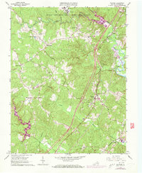
1966 Map of Stafford
USGS Topo · Published 1973About this map
Stafford serves as a central hub in this Virginia landscape, situated within a complex network of waterways including Aquia Creek, Accokeek Creek, and Potomac Creek. The area’s spiritual and civic history is well-represented by long-standing congregations such as Aquia Ch and Ebenezer Ch, while the Crucifix Monument stands as a notable roadside landmark. To the north, the massive presence of the Marine Corps Development and Education Command and Camp Barrett signifies the region's enduring military importance.
Find a feature on this map
43 named features on this map. Tap any name to fly to it.
Don’t see what you’re looking for? This feature index may not catch every label — zoom into the map to look around manually.
Map Details
Editions of this 1966 Stafford Map
4 editions found
Other maps of this area

1887 · Spottsylvania
USGS Topo · 1:125,000

1889 · Fredericksburg
USGS Topo · 1:125,000

1890 · Mt. Vernon
USGS Topo · 1:125,000

1891 · Mt. Vernon
USGS Topo · 1:125,000

1892 · Fredericksburg
USGS Topo · 1:125,000

1892 · Spottsylvania
USGS Topo · 1:125,000

1894 · Warrenton
USGS Topo · 1:125,000

1894 · Fredericksburg
USGS Topo · 1:125,000

1894 · Mt. Vernon
USGS Topo · 1:125,000

1897 · Mt. Vernon
USGS Topo · 1:125,000