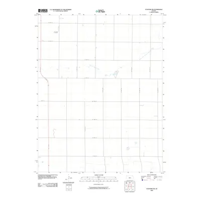
2009 Map of Stafford SW
USGS Topo · Published 2009About this map
Rose Valley Cemetery is a prominent point of interest in this agricultural region of Pratt County, situated north of SE 70th St and west of SE 10th Ave. The landscape is defined by the winding course of the North Fork Ninnescah River, which meanders through the northeast and east-central portions of the quadrangle. Transportation is anchored by the corridor of US Hwy 281, which cuts diagonally across the western edge of the area. This survey reflects the systematic section-line road network typical of the Kansas plains, with thoroughfares like NE 110th St and NW 1st Ave providing access to the distributed rural farmsteads and open fields that characterize the local economy.
Find a feature on this map
22 named features on this map. Tap any name to fly to it.
Don’t see what you’re looking for? This feature index may not catch every label — zoom into the map to look around manually.
Map Details
Editions of this 2009 Stafford SW Map
This is the sole edition of this map. No revisions or reprints were ever made.
Other maps of this area

1892 · Pratt
USGS Topo · 1:125,000

1894 · Pratt
USGS Topo · 1:125,000

1955 · Pratt
USGS Topo · 1:250,000

1959 · Pratt
USGS Topo · 1:250,000

1967 · Cairo
USGS Topo · 1:24,000

1968 · Pratt
USGS Topo · 1:24,000

1968 · Coats NE
USGS Topo · 1:24,000
1971 · Preston
USGS Topo · 1:24,000

1971 · Stafford
USGS Topo · 1:24,000
1971 · Byers
USGS Topo · 1:24,000