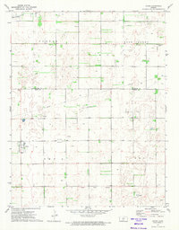
1971 Map of Byers
USGS Topo · Published 1974About this map
The small town of Byers anchors this western Kansas landscape, which is defined by a dense grid of section lines and the productive machinery of the energy industry. An extensive Oil Field spreads across the terrain, marked by numerous wells and a network of pipelines that connect localized infrastructure like the Compressor Station. Beyond the industrial activity, the map reveals the social fabric of the rural community through landmarks such as the Townhall and Antrim Ch, situated in the vicinity of Rose Valley.
Find a feature on this map
9 named features on this map. Tap any name to fly to it.
Don’t see what you’re looking for? This feature index may not catch every label — zoom into the map to look around manually.
Map Details
Editions of this 1971 Byers Map
This is the sole edition of this map. No revisions or reprints were ever made.
Other maps of this area

1892 · Pratt
USGS Topo · 1:125,000

1894 · Pratt
USGS Topo · 1:125,000

1955 · Pratt
USGS Topo · 1:250,000

1959 · Pratt
USGS Topo · 1:250,000

1968 · Pratt
USGS Topo · 1:24,000

1968 · Cullison
USGS Topo · 1:24,000

1968 · Coats NE
USGS Topo · 1:24,000
1971 · Hopewell
USGS Topo · 1:24,000
1971 · Stafford SW
USGS Topo · 1:24,000
1972 · Macksville
USGS Topo · 1:24,000