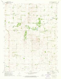
1971 Map of Stafford SW
USGS Topo · Published 1974About this map
The Old Indian Treaty Boundary cuts across the southern portion of this landscape, marking a historical division that still influences local property and section lines between Stafford Co and Pratt Co. In the early 1970s, the region was characterized by the extensive development of the Iuka-Carmi Oil and Gas Field, with numerous Oil Wells and a network of pipelines weaving through the township sections of Rose Valley and Union. The Missouri Pacific railroad runs along the southern edge, supporting the area's industrial and agricultural output. Along the North Fork Ninnescah River, specialized land use is evident at the Fish Hatchery, while local genealogy is rooted in sites like the Rose Valley Cem and a smaller Cem further east. This topographic study documents a period when petroleum extraction and traditional agriculture coexisted alongside early frontier survey markers.
Find a feature on this map
14 named features on this map. Tap any name to fly to it.
Don’t see what you’re looking for? This feature index may not catch every label — zoom into the map to look around manually.
Map Details
Editions of this 1971 Stafford SW Map
This is the sole edition of this map. No revisions or reprints were ever made.
Other maps of this area

1892 · Pratt
USGS Topo · 1:125,000

1894 · Pratt
USGS Topo · 1:125,000

1955 · Pratt
USGS Topo · 1:250,000

1959 · Pratt
USGS Topo · 1:250,000

1967 · Cairo
USGS Topo · 1:24,000

1968 · Pratt
USGS Topo · 1:24,000

1968 · Coats NE
USGS Topo · 1:24,000
1971 · Preston
USGS Topo · 1:24,000

1971 · Stafford
USGS Topo · 1:24,000
1971 · Byers
USGS Topo · 1:24,000