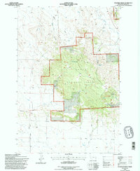
1993 Map of Stagville Draw
USGS Topo · Published 1996About this map
Custer National Forest dominates this section of Carter County, characterized by the prominent high ground of the Chalk Buttes and the deeply incised drainages of the Montana plains. The map illustrates a landscape of working rangeland and protected timber, where private holdings like Pierce Ranch and Peabody Ranch sit alongside public lands. This era of land management is evidenced by the network of service roads and the Pipeline corridor that cuts across the southwestern corner. Water sources are critical identifiers in this arid environment, ranging from named seasonal flows like Dead Horse Draw and Little Beaver Creek to essential points like Stagville Spring and Thompson Spring. The inclusion of Ekalaka Park and various established trails reflects the area's dual role as both a remote agricultural zone and a recreational resource within the national forest system.
Find a feature on this map
31 named features on this map. Tap any name to fly to it.
Don’t see what you’re looking for? This feature index may not catch every label — zoom into the map to look around manually.
Map Details
Editions of this 1993 Stagville Draw Map
This is the sole edition of this map. No revisions or reprints were ever made.
Other maps of this area

1954 · Ekalaka
USGS Topo · 1:250,000

1956 · Ekalaka
USGS Topo · 1:250,000

1958 · Ekalaka
USGS Topo · 1:250,000

1965 · Ekalaka
USGS Topo · 1:250,000

1979 · Beaver Flats South
USGS Topo · 1:24,000

1979 · Dead Boy Divide
USGS Topo · 1:24,000

1979 · Chalk Buttes
USGS Topo · 1:24,000

1979 · Ekalaka
USGS Topo · 1:24,000

1979 · Beaver Flats North
USGS Topo · 1:24,000

1980 · Taylor Hills
USGS Topo · 1:24,000