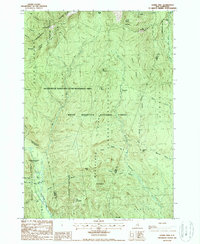
1987 Map of Stairs Mountain
USGS Topo · Published 1987About this map
Willey House PO and the small siding at Bemis anchor the southwestern corridor of this landscape, marking the historic human footprint along the Saco River. This 1987 survey details the complex network of land grants and purchases that historically partitioned this section of the White Mountain National Forest, including Sargents Purchase, Cutts Grant, and Beans Grant. These administrative boundaries overlay a terrain defined by high peaks such as Mt Pierce and Mt Isolation, and the dramatic Frankenstein Cliff overlooking the notch.
Find a feature on this map
56 named features on this map. Tap any name to fly to it.
Don’t see what you’re looking for? This feature index may not catch every label — zoom into the map to look around manually.
Map Details
Editions of this 1987 Stairs Mountain Map
2 editions found
Other maps of this area

1893 · Mt. Washington
USGS Topo · 1:62,500

1893 · Gorham
USGS Topo · 1:62,500

1894 · North Conway
USGS Topo · 1:62,500

1895 · Crawford Notch
USGS Topo · 1:62,500

1896 · Mt. Washington
USGS Topo · 1:62,500

1896 · Crawford Notch
USGS Topo · 1:62,500

1896 · North Conway
USGS Topo · 1:62,500

1896 · Gorham
USGS Topo · 1:62,500

1935 · Mt. Washington
USGS Topo · 1:62,500

1937 · Gorham
USGS Topo · 1:48,000