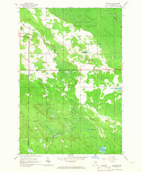
1964 Map of Stalwart
USGS Topo · Published 1965About this map
Stalwart serves as the primary settlement on this mid-century survey, located near the Stalwart Cem and a designated Fairground. The landscape is defined by the vast Gogomain Swamp and the sprawling Munuscong State Forest, illustrating the transition from cleared agricultural land to dense Upper Peninsula wetlands and timber. The South Branch Munuscong River and Munuscong River drain this low-lying area, which is punctuated by glacial features like Birch Hill and Hungry Hill. Several small lakes named for local individuals or families, including McAdams Lake, Sam Taylor Lake, and Fulmer Lake, are scattered throughout the forest. The boundary between Mackinac County and Chippewa County runs through the southwestern portion of the sheet, while Swede Rd provides one of the few named access routes into the more remote forested sections.
Find a feature on this map
19 named features on this map. Tap any name to fly to it.
Don’t see what you’re looking for? This feature index may not catch every label — zoom into the map to look around manually.
Map Details
Editions of this 1964 Stalwart Map
This is the sole edition of this map. No revisions or reprints were ever made.
Other maps of this area

1931 · Pickford SE
USGS Topo · 1:31,680

1953 · Munuscong
USGS Topo · 1:24,000

1953 · Munuscong NE
USGS Topo · 1:24,000
1953 · Pickford
USGS Topo · 1:24,000

1954 · Sault Sainte Marie
USGS Topo · 1:250,000

1955 · Cheboygan
USGS Topo · 1:250,000

1956 · Sault Sainte Marie
USGS Topo · 1:250,000

1957 · Sault Sainte Marie
USGS Topo · 1:250,000

1958 · Cheboygan
USGS Topo · 1:250,000

1958 · Sault Sainte Marie
USGS Topo · 1:250,000