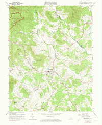
1964 Map of Stanardsville
USGS Topo · Published 1973About this map
Stanardsville serves as the focal point of this Greene County landscape during the mid-1960s, situated at the junction of South Run and Stanardsville Run. The map illustrates a rural Virginia community defined by its educational and spiritual centers, such as Monroe High Sch, Stanardsville Sch, and several denominations including South River Ch and Middle River Ch. To the northwest, the terrain rises sharply toward Saddleback Mountain within the protected boundaries of Shenandoah National Park. The land is deeply divided by a network of ridges and watercourses, including Turkey Ridge and the Conway River, which forms the boundary between Madison and Greene Counties. Smaller settlements like Lydia, Kinderhook, and Geer are connected by winding roads and utility infrastructure, including a prominent pipeline and a compressor station that reflect the technological footprints of the era.
Find a feature on this map
60 named features on this map. Tap any name to fly to it.
Don’t see what you’re looking for? This feature index may not catch every label — zoom into the map to look around manually.
Map Details
Editions of this 1964 Stanardsville Map
4 editions found
Other maps of this area

1892 · Gordonsville
USGS Topo · 1:125,000

1892 · Harrisonburg
USGS Topo · 1:125,000

1930 · Madison
USGS Topo · 1:48,000

1931 · University
USGS Topo · 1:62,500

1933 · Madison
USGS Topo · 1:62,500

1935 · Charlottesville
USGS Topo · 1:62,500

1935 · University
USGS Topo · 1:62,500

1937 · Elkton
USGS Topo · 1:62,500

1939 · Charlottesville
USGS Topo · 1:62,500

1949 · Charlottesville
USGS Topo · 1:250,000