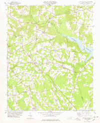
1978 Map of Stancils Chapel
USGS Topo · Published 1978About this map
Stancils Chapel serves as a central hub in this rural landscape where Johnston, Wilson, and Nash counties converge. The 1970s terrain is defined by a dense network of country churches and family-named crossroads, such as Stilleys Crossroads and Moores Crossroads, which highlight the traditional community structures of the North Carolina coastal plain. Significant water features like the Buckhorn Reservoir and the winding course of the Little River dominate the topography, while the Little River Picnic Area suggests the area's role in local recreation. The map reveals a transition from agricultural land to more developed water management, particularly evident in the inundation patterns of Mill Branch and Turkey Creek feeding into the reservoir. Genealogists will find a high density of rural cemeteries and historical congregations, including Sylvia Chapel and New Jerusalem Ch, marking the family footprints across this tri-county border region.
Find a feature on this map
38 named features on this map. Tap any name to fly to it.
Don’t see what you’re looking for? This feature index may not catch every label — zoom into the map to look around manually.
Map Details
Editions of this 1978 Stancils Chapel Map
This is the sole edition of this map. No revisions or reprints were ever made.
Other maps of this area

1902 · Kenly
USGS Topo · 1:62,500

1902 · Spring Hope
USGS Topo · 1:62,500

1903 · Kenly
USGS Topo · 1:62,500

1904 · Springhope
USGS Topo · 1:62,500

1953 · Raleigh
USGS Topo · 1:250,000

1954 · Raleigh
USGS Topo · 1:250,000

1964 · Flowers
USGS Topo · 1:24,000

1964 · Selma
USGS Topo · 1:62,500

1964 · Selma
USGS Topo · 1:24,000
1968 · Zebulon
USGS Topo · 1:24,000